


Plan d'Hotonnes A

alexbnmr
User

Length
104 km

Max alt
1499 m

Uphill gradient
3164 m
Km-Effort
146 km

Min alt
256 m

Downhill gradient
3164 m
Boucle
Yes
Creation date :
2014-12-10 00:00:00.0
Updated on :
2014-12-10 00:00:00.0
4h44
Difficulty : Very difficult

FREE GPS app for hiking
 SityTrail
IGN / Geographical institutes
SityTrail Plus
The world is yours!
About
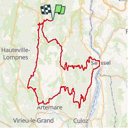
Trail Cycle of 104 km to be discovered at Auvergne-Rhône-Alpes, Ain, Haut Valromey. This trail is proposed by alexbnmr.
Description
Col de la Biche
Col du Grand Colombier (Anglefort - Seyssel)


Positioning
Country:
France
Region :
Auvergne-Rhône-Alpes
Department/Province :
Ain
Municipality :
Haut Valromey
Location:
Hotonnes
Start:(Dec)
Start:(UTM)
709266 ; 5102016 (31T) N.
Comments